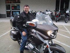
It wasn't a complete day off as I rode to breakfast to meet my friend Mindy who is struggling in a job search. She is a benefits specialist and tires of working for HR managers who have no concept of the benefits part of their business and its requirements.
There was a poker run that I had thought I would go to afterwards, but after spending all day, yesterday at a masonic function, I needed a day to rest and... well, do things like making a note on the blog and just seeing what kind of fun there might be on the Internet.
So, I caught up a bit with the bmwbmw web page and the Adventure Riders' page that needed an update since I've let my regular web page hosting expire. After that my landlady, neighbor, and riding companion, Susan, dropped in with coffee and a request to look at South Carolina motorcycle riding destinations. I showed her Google Earth.
First, we explored the coastline north of Charlestown. Then we returned and spotted the link to the Hunley, "The Secret Weapon of the Confederacy."
"I want to visit that!" she exclaimed.
It did seem like a good destination, for me, also.
Next, we explored the South Carolina coast line. As we did so, I looked enviously at all the terrain that would be out of reach of motorcycle explorations. I recounted what a former priest friend had told me, in Puerto Rico. He and his wife both enjoyed sailing. As he had been successful as a dentist, before becoming a priest, he could aford sailboats and the time to enjoy them. He had told me about the way one could get to places by sailboat that were unreachable by car: How before roads and cars transportation along the coast was by ship and settlements were created to meet the needs of those travelers. Many of such places are now bypassed by in-land roads and highways so that a visit to them is a visit back in time.
As I poured over the islands and beaches, I remembered this, and noted how many places might also be unreachable by sail boat -- given sand bars and shallow drafts. It made me think that someday there will be a market for personal dirrigibles.
Susan agreed to join me for an afternoon movie. We plan to see "Man of the Year." Then she took off to checkout an animal rescue operation that our friend Karin called about. I continued to explore Google Earth. I need to make a list of places that I want to visit.
Friday night, Todd Suda joined me for Oktoberfest at the Silver Spring American Legion post. He described the roads of southern Missouri, how they follow geography that was carved out by waters running off, below the ice sheets of earlier ages.
 So, I visited Brandon, Missouri and traced out some of the nearby roads, discovering a link to a National Geographic article about East Wind. After that I traveled by Google Earth to visist my mother's address in Tonopah, NV and travelled the nearby highways to discover a place to camp at Cave Lake State Park.
I returned to Tonopay, followed 95 south to Las Vegas. Where did 95 go from there? I discovered it was named "Veterans Memorial Highway and it led to Searchlight, NV and on to Needles, California with it's combination RV and Marine park and the beckoning intersection with old highway 66.
Somehow, I found Joshua Tree National Park, then ended up in Oceanside, California where GoogleEarth provided a very inviting video. http://turnhere.com/co_GoogleEarth.aspx?filmname=oceanside

No comments:
Post a Comment